

What Is a Marine Chartplotter and How It Works

Table of Contents
- What Is a Marine Chartplotter and How It Works
- Chartplotter vs GPS: What Sets Them Apart
- Marine Chartplotter Features That Matter Most
- Chartplotter and Fish Finder: How They Work Together
- Marine Chartplotter Installation and Setup
- Chartplotter Limitations and Safe Cross-Checking
- Choosing the Right Marine Chartplotter for Your Boat
- Conclusion
- Frequently Asked Questions
Last Updated: October 6, 2026
What Is a Marine Chartplotter and How It Works
A marine chartplotter is an onboard electronic navigation device that combines a GPS receiver with an electronic chart display, showing your vessel's position on a detailed marine map in real time. The GPS tells the unit where you are, and the chart shows you what surrounds that spot. That pairing is what makes a chartplotter different from a basic GPS handset.
The basic process runs in four steps:
- The GPS antenna fixes your position using satellite signals.
- The chartplotter matches that position to an electronic chart.
- The screen draws your boat as an icon on the chart.
- As you move, the icon moves with you.
That's the whole idea. Everything else, from route planning to sonar overlays, builds on those four steps.
The GPS-to-Chart Process in Plain Language
Think of the chartplotter as two devices working as one. The GPS receiver is the "where am I" half. The chart library is the "what's around me" half.
The receiver listens to satellites and works out latitude and longitude. That fix updates several times per second. The plotter then places that position onto an electronic chart, which contains depth soundings, buoys, channels, and hazards. NOAA Office of Coast Survey navigation data publishes much of the official chart data used in these systems.
The result is a live picture of your boat on the water. Move the boat, and the icon moves with it.
Chartplotter vs GPS: What Sets Them Apart
A GPS unit tells you where you are. A chartplotter tells you where you are and what's around you. That single difference drives most buying decisions, but it also hides a second problem: most shoppers confuse four different devices that all look alike on a spec sheet.
Here is the plain-language breakdown.
- GPS receiver: a positioning engine. It listens to satellites and outputs latitude, longitude, speed, and time. On its own it has no map. A handheld trail GPS is this plus a tiny screen.
- Chartplotter: a GPS receiver plus an electronic chart display. The chart is the point. It shows channels, depth contours, buoys, hazards, and your live position icon on top of them.
- Fish finder (sounder): a depth-and-echo device. It uses a transducer to send sound pulses into the water and reads the returns to show depth, bottom structure, and fish. It does not know where you are on a chart unless it is paired with a GPS.
- Multifunction display (MFD): a networked screen that can run chartplotter, fish finder, radar, autopilot control, and instrument data at once. A chartplotter is one function an MFD performs.
A chartplotter vs GPS comparison usually comes down to three practical differences:
- Visual context: charts show channels, depths, and hazards; a plain GPS shows a coordinate and a breadcrumb line.
- Screen size and mounting: plotters run larger displays built for a helm; handheld GPS units are pocket-sized.
- Integration: plotters connect to sonar, radar, autopilots, and engine data over NMEA 2000 or NMEA 0183; a standalone GPS typically does not.
If you only need a position fix for hiking or a dinghy, a GPS is enough. If you need to see where that position sits relative to shoals, shipping lanes, and a marked channel, you want a chartplotter. If you also want depth and fish, you want a chartplotter with a built-in sounder or an MFD that runs both.
Marine Chartplotter Features That Matter Most
The features that matter most are the ones you'll actually use: a readable display, reliable chart data, and simple route tools. Everything else is secondary.
Start with the screen. A bright, high-resolution touchscreen display stays readable in direct sun. Keyed controls still help in rough water when wet hands struggle with touch.
Then look at these core functions:
- Chart data and map coverage for your cruising area
- Route planning and waypoint creation
- Position tracking and location confirmation
- Chart orientation options
- Split screen views for chart plus sonar
- Device integration through NMEA 2000 and similar networks
Route Planning and Waypoint Creation
Route planning is the process of building a path from your current position to a destination, marked by waypoints. A waypoint is a saved navigation point, a specific spot on the chart you name and store. Mastering these digital waypoints provides a reliable foundation for understanding the core principles behind traditional navigation methods that remain essential for every mariner.
To build a route:
- Open the chart page.
- Tap or select "New Route."
- Place your first waypoint at the start.
- Add waypoints along the intended path.
- Save and name the route.
The plotter then draws a line through your waypoints and can show a predicted track based on your speed and course. You can follow it visually or hand it to an autopilot on a compatible system.
Chart Orientation: North-Up and Course-Up
Chart orientation controls which way the map faces on screen. The two common modes are north-up and course-up.
- North-up: the top of the screen always points north. Your boat icon rotates as you turn. Best for planning.
- Course-up: the top of the screen follows your heading. The chart rotates instead of the boat. Best for steering.
Most boaters run course-up while underway and switch to north-up when planning a route. Neither is "correct." It comes down to what keeps your eyes on the water longer.
Chartplotter and Fish Finder: How They Work Together
A chartplotter and fish finder work together by sharing one screen: the chart shows your position, and the sounder shows what's below the boat. The fish finder half uses a transducer to send sound pulses into the water and read the echoes that return. Those echoes reveal depth and fish.
Garmin GPSMAP 1243 Chartplotter GN+ [010-02367-60] →
On many modern units, this is built in. A multifunction display (MFD) runs chart, sonar, and radar on one screen. You can set a split screen with the chart on one side and the sounder on the other.
What most guides miss is the transducer choice. The display gets all the attention, but the transducer decides how well the sonar actually reads. Match it to your depth range and hull type before you buy.
Marine Chartplotter Installation and Setup
Marine chartplotter installation means mounting the display, wiring power, connecting sensors, and loading chart data. Most DIY owners can handle a basic install in an afternoon, but the details below are where most first-time installs go wrong.
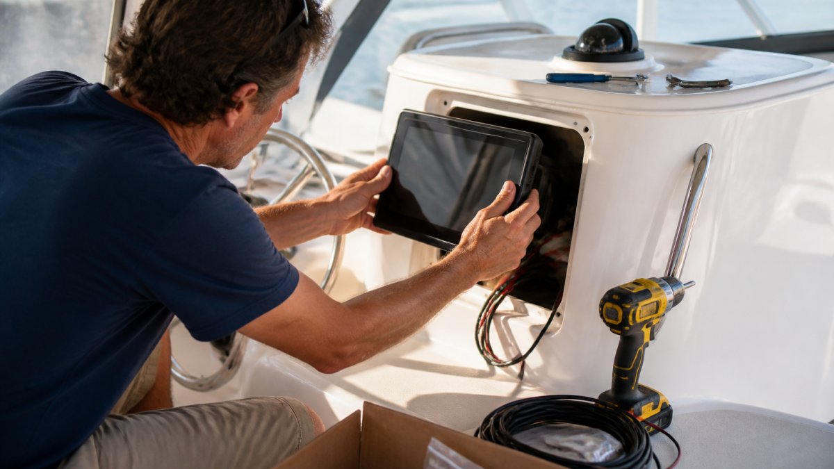
Plan the location first. You want the screen visible from the helm and reachable without leaving the wheel. Then run the steps:
- Choose a mounting spot with clear sky access for the GPS antenna. Fiberglass and canvas are fine; metal and carbon fiber can block satellite reception.
- Cut or fit the mounting bracket, and seal any fastener holes with marine sealant.
- Run the power and data cable to a switched circuit on the boat's DC panel.
- Connect the transducer and any network cables.
- Load or insert your chart card.
- Power on and confirm the position fix before you leave the dock.
Power, Sensors, and Connectivity
Power, sensors, and connectivity decide how well your plotter plays with the rest of the boat. Most units run on 12-volt DC power, so wire to a fused, switched circuit.
Sensors include the GPS antenna (often built into the display, sometimes a separate puck), the depth transducer, and wind or speed instruments. Transducer mounting matters as much as the display: a transom-mount skimmer works for planing hulls, while a through-hull or in-hull shoot-through puck suits sailboats and displacement hulls that need clean water flow at low speed.
Connectivity covers network standards like NMEA 2000 and NMEA 0183, plus Wi-Fi for updates. NMEA 2000 is the modern backbone, a single powered trunk cable that devices tap into with drop cables. NMEA 0183 is the older serial standard, still common on autopilots and older instruments.
Chartplotter Limitations and Safe Cross-Checking
A chartplotter is an aid, not an autopilot for judgment. Charts can be outdated, GPS can drift, and electronics can fail. Safe cross-checking means confirming what the screen shows against what you can see.
Watch for these limits:
- Chart age: surveys and depths can lag behind shifting shoals.
- Position error: GPS accuracy can degrade near obstructions (GPS Accuracy).
- Screen failure: a dead display leaves you without the picture.
- Reduced visibility: fog and glare cut what your eyes can confirm.
Carry a backup: a paper chart, a second GPS, or both. That's how you keep situational awareness when the electronics quit.
Choosing the Right Marine Chartplotter for Your Boat
The right marine chartplotter matches your boat, your waters, and your budget. Screen size is the first call. A small center console does fine with a 7-inch display. A larger helm benefits from a 9-inch or 12-inch unit.
| Screen Size | Best For | Example Unit | Price |
|---|---|---|---|
| 7-inch | Small boats, tiller helms | Garmin GPSMAP 743 Chartplotter GN+ | $1,199.99 |
| 9-inch | Mid-size cruisers, sailboats | Raymarine Axiom+ 9 MFD Chartplotter | $1,299.99 |
| 12-inch | Larger helms, offshore | Garmin GPSMAP 1243 Chartplotter GN+ | $2,899.99 |
For most sailboat owners, we recommend the Garmin GPSMAP 743 Chartplotter GN+. Its 7-inch display has 60% more pixels than the previous generation, and it ships with preloaded Garmin Navionics+ coastal charts and inland mapping.
![Garmin GPSMAP 743 Chartplotter GN+ [010-02365-60]](https://cdn.shopify.com/s/files/1/0842/4914/9751/files/97011XL.jpg?v=1775847907)
If you want a bigger helm screen, the Garmin GPSMAP 1243 Chartplotter GN+ gives you a 12-inch high-resolution touchscreen with the same preloaded chart package and Auto Guidance+ planning tools.
![Garmin GPSMAP 1243 Chartplotter GN+ [010-02367-60]](https://cdn.shopify.com/s/files/1/0842/4914/9751/files/97019XL.jpg?v=1775847909)
For Raymarine fans, the Raymarine Axiom+ 9 MFD Chartplotter runs a quad-core processor and the LightHouse 3 operating system, with an IPS display that's 25% brighter than earlier models.
![Raymarine Axiom+ 9 - 9" MFD Chartplotter [E70636]](https://cdn.shopify.com/s/files/1/0842/4914/9751/files/85044XL.jpg?v=1775846561)
Conclusion
Picking the wrong chartplotter, or one that won't talk to your existing onboard electronics, is the fastest way to waste a season. Charleston Yachting stocks premium marine electronics from brands like Garmin, B&G, and Harken, with same-day shipping and expert-curated inventory for both racers and weekend sailors. Shop All at Charleston Yachting and get your helm set up right the first time.
Frequently Asked Questions
What is a marine chartplotter?
A marine chartplotter is a dedicated navigation device that combines a GPS receiver with electronic marine charts on a display screen. It shows your vessel's position, heading, and speed overlaid on detailed nautical charts. Unlike a basic GPS unit, a chartplotter gives you a visual map of your surroundings, including depth contours, navigational aids, and hazards. It is a core part of onboard electronics for recreational and commercial vessels.
What is the difference between a chartplotter and a GPS?
A GPS receiver calculates your position using satellite signals but typically shows only coordinates or a basic map. A chartplotter takes that GPS data and displays it on detailed marine charts with depth soundings, buoys, and route lines. In short, every chartplotter uses GPS, but not every GPS unit functions as a chartplotter. The chartplotter adds the visual chart layer that makes navigation decisions faster and more accurate.
Does a chartplotter need an internet connection to work?
No. A chartplotter receives position data from GPS satellites, which works without internet or cellular service. Charts are stored onboard, either preloaded or on a microSD card. You only need internet to download chart updates, sync waypoints, or access online services. Once charts are loaded, you can navigate offshore with no connectivity at all.
Can a chartplotter show depth and sonar?
Yes, when connected to a compatible sonar module and transducer. Many modern units like the Garmin GPSMAP 1243 and Raymarine Axiom+ series support sonar input, displaying depth readings and fish-finding views directly on the chartplotter screen. This integration lets you see bottom structure alongside your chart position. A separate fish finder is not required if your chartplotter supports sonar.