

How to Choose Marine Chartplotter Charts and Maps

Last Updated: November 5, 2026
Quick Summary
To choose chartplotter charts, first confirm your display's make and model supports that chart brand's format, since each major brand runs its own ecosystem. Then decide between raster and vector, keep electronic updates current, and match coverage to the water you actually boat.
- Garmin units read Navionics+ and BlueChart g3, Raymarine runs LightHouse Charts, and B&G ships with C-MAP Discover.
- Raster charts are fixed images, while vector charts redraw from data and support object querying and autorouting.
- Free NOAA chart data rarely loads on a branded chartplotter without conversion, though it works in some PC and tablet apps.
- Most chart brands sell roughly three coverage tiers: inland lakes, coastal, and offshore/bluewater.
- Buy the display and chart together, because bundles usually cost less than the two pieces bought apart.
Table of Contents
- Start With Chartplotter Chart Compatibility, Not the Chart
- Raster vs Vector Nautical Charts: What Changes on the Screen
- Electronic Nautical Chart Updates and Why They Matter
- Free NOAA Nautical Charts and Where They Fit on a Chartplotter
- Match Chart Coverage and Detail to How You Actually Boat
- Chart Cards, Bundles, and Chartplotters Worth Pairing
- Five Chart-Buying Mistakes That Cost You Money
- Pick Your Chart Card and Chartplotter Together
- Frequently Asked Questions
Start With Chartplotter Chart Compatibility, Not the Chart
The most expensive chart card is useless if your display cannot read it. Chartplotter charts compatibility comes first. A common scenario is a boater buying a bargain card online, then discovering their unit only accepts one brand's format.
Every major brand runs its own chart ecosystem. Garmin units read Garmin Navionics+ and LakeVü or BlueChart g3 data. Raymarine displays run LightHouse Charts. B&G units ship with C-MAP Discover. Cross-brand reading is the exception. Because chart compatibility is only one part of choosing a display, reading live sonar also depends on understanding how the unit presents what is beneath the boat.
So check three things before you spend anything:
- Your display's make and model
- Which chart brands that model officially supports
- Whether the card slot takes microSD or a full-size card
Match the Chart Format to Your Brand's Chart Store
Each brand sells charts through its own store, which defines what your unit can load.
Buy chartplotter charts that match your display's supported formats.
Check Card Type, Storage, and Region Locking
Two physical details trip up buyers: card size (microSD, standard SD, or proprietary on some older models) and region locking, since cards are sold by region and a card built for one coastline will not include another.
Confirm the card type in your owner's manual, then confirm the region on the product listing before checkout.
Raster vs Vector Nautical Charts: What Changes on the Screen
Raster charts are digital pictures of paper charts, while vector charts are built from data layers you can turn on and off. That difference drives how the chart looks, redraws, and behaves when you zoom or pan.
Raster charts show a digital image of the paper chart, with the same symbols, colors, and placement.
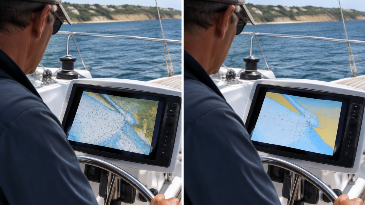
How Each Format Behaves on the Water
The differences that matter at the helm are practical, not cosmetic:
- Zoom behavior. A raster chart is a fixed-resolution image; zoom past its native scale and you get larger pixels, not new soundings. A vector chart redraws from data, so zooming in can reveal hidden detail.
- Object querying. On a vector chart you can tap a buoy, light, or wreck and read its attributes. On a raster chart the symbol is ink; there is nothing to query.
- Display control. Vector charts let you toggle layers: depth contours, shallow-water shading, safety contours, and clutter. Raster charts show one fixed picture.
- Redraw and panning. Vector charts generally redraw and pan faster on modern processors. On older units, a large raster chart can feel sluggish.
- Autorouting. Vector charts support autorouting because the unit can read depth and obstruction data; raster charts generally cannot.
- Memory and card size. Raster packs are large image files; vector packs store data compactly, so one card often covers more water.
When a Raster Chart Is the Safer Choice
Raster wins when you want the chart to look exactly like the paper version you trust. Some commercial operators and older skippers prefer this for familiarity, and a fixed image cannot hide a feature through a layer setting. The trade-off is less interactivity, no object querying, and weaker zoom performance.
The caution is layer discipline, it is easy to turn off a layer and wonder why a shoal looks clear. Check visible layers before trusting a clean screen.
Electronic Nautical Chart Updates and Why They Matter
Charts go stale. Buoys move, channels shift, and aids to navigation get renumbered. Electronic nautical chart updates keep your display aligned with current conditions, and skipping them is one of the quietest safety risks in marine navigation.
Watch out: an out-of-date chart can show a buoy where none exists, and that error tends to surface at the worst moment. Set a reminder to check for updates before every season, and again before any long passage.
If you need a walkthrough for your specific unit, our guide on how to update marine chartplotter software covers the step-by-step process.
Free NOAA Nautical Charts and Where They Fit on a Chartplotter
Free NOAA nautical charts are official government chart data, and they are genuinely useful. The catch is that free data rarely drops straight onto a branded chartplotter without conversion.
NOAA provides free chart data through its official chart products, and the NOAA Office of Coast Survey chart resources explain what is available and in what format. That data works well in PC navigation software and tablet apps that accept ENC files.
On a dedicated chartplotter, the story changes.
Garmin ECHOMAP UHD2 74CV Chartplotter/Fishfinder Combo w/US Coastal Maps →
Match Chart Coverage and Detail to How You Actually Boat
Coverage should follow your actual water, not your ambitions. A coastal cruiser needs different detail than a lake angler, and oversized coverage wastes money on water you will never see. The right coverage for a 16-foot lake boat is not the right coverage for a flybridge sportfisher, even in the same state.
Start with two questions:
- Where do I actually boat most weekends?
- Do I need inland lakes, coastal waters, or offshore coverage?
Then translate those answers into a coverage tier. Most chart brands sell in roughly three layers: inland lakes, coastal, and offshore/bluewater. The tier you buy should match the farthest water you routinely run, not the farthest water you dream about.
Coverage by Vessel and Use Case
Use this as a decision guide, then confirm the exact product names and regions on the chart maker's store:
- Small lake and river boats (under about 20 feet). Inland lake coverage is usually enough, high-detail lake contours and hazard marking, not coastal packages. A coastal card here is the most common wasted purchase we see.
- Coastal fishing boats and bay boats. Coastal coverage is the core purchase. Look for harbor detail plus nearshore soundings, and confirm the package includes your specific bays and inlets.
- Sailboats and club racers. Coastal coverage plus good harbor detail matters more than offshore bluewater, since you spend most time in channels, approaches, and starting areas.
- Offshore and bluewater boats. Offshore coverage adds passage-scale data and offshore features. If you routinely run beyond the coastal shelf, it earns its cost; if only occasionally, a coastal package plus a planning app may cover you.
- Boats with flybridges or dual stations. Coverage choice is the same, but confirm the card is readable at both stations and any shared network lets both displays see the same chart data. A second station with a different card is a common source of confusion.
Read the Coverage Description, Not the Marketing Name
Chart packages are sold by region, and boundaries do not always match how boaters think. Before checkout, review the coverage description and confirm the specific harbors and inlets you run.
Garmin's LakeVü g3 inland maps and BlueChart g3 coastal charts are sold as separate coverage types. If you want a real example of inland coverage in a compact unit, the Garmin ECHOMAP UHD2 53CV with US Inland Maps shows how preloaded regional mapping works in practice. For a deeper look at matching a unit to your fishing style, see our guide to the best marine chartplotter for saltwater fishing.

Watch out: a package covering your home water can still omit a neighboring inlet or lake you use seasonally, check the coverage list against your float plan, because region names are broader than the water they include.
Chart Cards, Bundles, and Chartplotters Worth Pairing
Bundles save money when the included chart matches your water. They waste money when it does not. The smart move is to pick the display and chart together, as one purchase.
A few pairings we would put on a boat today:
- Garmin ECHOMAP UHD2 74CV with US Coastal Maps and a GT20-TM transducer, $699.99. A 7-inch keyed display with CHIRP and ClearVü sonar, plus BlueChart g3 coastal coverage. A strong fit for coastal fishing boats.
- Raymarine Axiom+ 9 with LightHouse North America Chart, $1,399.99. A 9-inch IPS display with a quad-core processor and fast chart redraw, accepting LightHouse, Navionics, and C-MAP. Best for a big, bright screen and chart flexibility.
- B&G Vulcan 9 FS with C-MAP Discover Chart, $1,019.99. A 9-inch touchscreen built for sailors, with SailSteer and autopilot control. A natural pick for coastal cruising and club racing.
- Simrad GO9 XSE Radar Bundle with Halo20 radar, Active Imaging 3-in-1 transducer, and C-Map Discover chart. A complete radar-and-sonar package in one purchase.
If you want to compare multifunction displays side by side before deciding, our comparison of four MFDs for sailboat chartplotting breaks down the trade-offs. You can also see a full chartplotter bundle with a C-Map Discover chart to understand how pairing works in one box.
| Unit | Screen | Included Chart | Price | Best For |
|---|---|---|---|---|
| Garmin ECHOMAP UHD2 53CV | 5 in | LakeVü g3 inland | $449.99 | Small boats, inland lakes |
| Garmin ECHOMAP UHD2 74CV | 7 in | BlueChart g3 coastal | $699.99 | Coastal fishing boats |
| B&G Vulcan 9 FS | 9 in | C-MAP Discover | $1,019.99 | Sailboats, club racing |
| Raymarine Axiom+ 9 | 9 in | LightHouse North America | $1,399.99 | Big-screen coastal cruising |
Five Chart-Buying Mistakes That Cost You Money
Most chart mistakes are avoidable, and each one can cost real money. Here are five common ones.
- Buying a chart before checking compatibility. The card will not load, and returns eat your time.
- Buying coverage you will never use. Offshore packages on a lake boat are pure waste.
- Skipping updates. Stale data is a safety issue, not just an inconvenience.
- Assuming free NOAA data loads anywhere. It works in some apps, not in locked brand ecosystems.
- Buying the display and chart separately. Bundles usually cost less than the two pieces apart.
A common mistake is chasing the biggest coverage package. Match the card to your water first, then size up only when your boating changes.
Pick Your Chart Card and Chartplotter Together
Buying charts and displays as one decision saves money, returns, and frustration. Confirm compatibility, choose raster or vector for how you navigate, keep updates current, and match coverage to the water you actually run.
Charleston Yachting stocks displays and chart bundles from Garmin, B&G, and Raymarine, with same-day shipping.
Get started with Charleston Yachting and pair the right chart card with the right display the first time.
Frequently Asked Questions
How do I know whether a chart is compatible with my chartplotter?
Check the chart format your unit accepts before you buy anything. Garmin units take Garmin Navionics+ and LakeVü or BlueChart g3 data, Raymarine displays run LightHouse Charts, and B&G Vulcan 9 FS ships with C-MAP Discover. Confirm the card type, storage, and regional coverage on the listing before you buy.
What is the difference between raster and vector nautical charts?
Raster charts are scanned images of official paper charts. Every symbol looks exactly like the printed original, which many sailors find reassuring, but you cannot tap an object for details. Vector charts store features as data, so you can query a buoy, toggle layers, and shrink or enlarge the display without losing clarity.
Do chartplotter maps need to be updated, and how often?
Yes. Buoys move, channels shoal, and new hazards get charted, so electronic nautical chart updates keep your display aligned with current conditions. Update before each season and again before any long offshore passage. Check the chart version date on the unit itself, not just the purchase date, because a card can sit in inventory for months.
Are free NOAA nautical charts suitable for a chartplotter?
Free NOAA nautical charts are official and accurate, but they arrive as raster or ENC files rather than a branded chart card. They work well as a planning reference, but compatibility with a specific chartplotter should be confirmed before relying on them.
